Saint-Télesphore
Saint-Télesphore | |
|---|---|
 | |
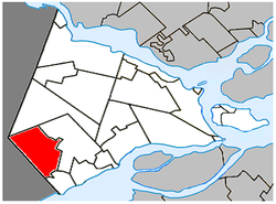
 Location within Vaudreuil-Soulanges RCM | |
| Coordinates: 45°18′N 74°23′W / 45.300°N 74.383°W[1] | |
| Country | Canada |
| Province | Quebec |
| Region | Montérégie |
| RCM | Vaudreuil-Soulanges |
| Constituted | 19 April 1877 |
| Government | |
| • Mayor | David Watson McKay |
| • Federal riding | Salaberry—Suroît |
| • Prov. riding | Soulanges |
| Area | |
• Total | 60.67 km2 (23.42 sq mi) |
| • Land | 60.10 km2 (23.20 sq mi) |
| Population (2021)[4] | |
• Total | 754 |
| • Density | 12.5/km2 (32/sq mi) |
| • Pop 2016-2021 | |
| • Dwellings | 352 |
| Time zone | UTC−5 (EST) |
| • Summer (DST) | UTC−4 (EDT) |
| Postal code(s) | |
| Area code(s) | 450 and 579 |
| Highways | |
| Website | saint-telesphore |
Saint-Télesphore (French pronunciation: [sɛ̃ telɛsfɔʁ]) is a municipality located in Vaudreuil-Soulanges Regional County Municipality, Quebec (Canada). The population as of the 2021 Canadian census was 754. The municipality is situated west of Saint-Polycarpe, south of Sainte-Justine-de-Newton, north of Rivière-Baudette and east of the provincial border near North Lancaster, Ontario.
The municipality is named for Pope Telesphorus, who reigned from 126 to 138 AD.[1] In addition to the village of Saint-Télesphore itself, the municipality also includes the community of Dalhousie or Dalhousie Station along the Canadian Pacific railway.
History
[edit]Settlement began around 1800 with the arrival of Scottish, Irish, and English immigrants. At that time, the place was called Rivière-Delisle, Lac-Saint-François, or Rivière-au-Beaudet.[1]
In 1877, the Parish Municipality of Saint-Télesphore was created, named after the parish that was formed one year earlier. In 1879, its post office opened.[1]
On August 7, 2010, the parish municipality changed its statutes to become a (regular) municipality.[1]
Demographics
[edit]| 2021 | 2016 | 2011 | |
|---|---|---|---|
| Population | 754 (-0.7% from 2016) | 759 (-0.4% from 2011) | 762 (-0.9% from 2006) |
| Land area | 60.10 km2 (23.20 sq mi) | 60.33 km2 (23.29 sq mi) | 60.42 km2 (23.33 sq mi) |
| Population density | 12.5/km2 (32/sq mi) | 12.6/km2 (33/sq mi) | 12.6/km2 (33/sq mi) |
| Median age | 43.6 (M: 44.0, F: 43.2) | 40.9 (M: 40.3, F: 41.8) | 43.1 (M: 43.5, F: 42.3) |
| Private dwellings | 352 (total) | 345 (total) | 361 (total) |
| Median household income | $54,592 | $47,601 |
|
| ||||||||||||||||||||||||||||||||||||
| Source: Statistics Canada[8] | |||||||||||||||||||||||||||||||||||||
Language
[edit]| Canada Census Mother Tongue - Saint-Télesphore, Quebec[8] | ||||||||||||||||||
|---|---|---|---|---|---|---|---|---|---|---|---|---|---|---|---|---|---|---|
| Census | Total | French
|
English
|
French & English
|
Other
| |||||||||||||
| Year | Responses | Count | Trend | Pop % | Count | Trend | Pop % | Count | Trend | Pop % | Count | Trend | Pop % | |||||
2011
|
765
|
655 | 85.62% | 80 | 10.46% | 20 | 2.61% | 10 | 1.31% | |||||||||
2006
|
765
|
630 | 82.35% | 120 | 15.69% | 0 | 0.00% | 15 | 1.96% | |||||||||
2001
|
775
|
660 | 85.16% | 105 | 13.55% | 10 | 1.29% | 0 | 0.00% | |||||||||
1996
|
815
|
730 | n/a | 89.57% | 85 | n/a | 10.43% | 0 | n/a | 0.00% | 0 | n/a | 0.00% | |||||
Local government
[edit]
List of former mayors:[9]
- Camille Gourgon (1878–1883)
- Jean Baptiste Campeau (1883–1884, 1885–1886)
- Athanase Daou (1884–1885, 1886–1889)
- Joseph Pilon (1889–1893, 1897–1899, 1902–1905)
- Louis Charlebois (1893–1897)
- Joseph Antoine Moyse Leroux (1899–1902, 1917-1919)
- Joseph Moyse Beauchamp (1905–1909)
- François Xavier Cuillierier (1909–1913)
- Louis Sauvé (1913–1914)
- Zotique Dicaire (1914–1917)
- Joseph Alfred Théodule Pilon (1919–1923)
- Joseph Arthur Hyacinthe St. Denis (1923–1927)
- Joseph Alfred Louis Charlebois (1927–1939)
- Joseph Samuel Evariste Braseau (1939–1953)
- Joseph Arcade Napoléon Bruno St-Denis (1953–1959)
- Joseph-Elzéar-Rosario-Richard Gaston Pilon (1959–1963)
- Joseph Jean-Baptiste Rémi Sauvé (1963–1981, 1987–1999)
- Joseph Marcel Eléonore Descent (1981–1983)
- Robert Bourgon (1983–1987, 1999–2003)
- Joseph Albert Patrice Claude Cyr (2003–2009)
- Yvon Bériault (2009–2021)
- David Watson McKay (2021–present)
Education
[edit]Commission Scolaire des Trois-Lacs operates Francophone schools.[10]
- École du Val-des-Prés Immaculée-Conception
Lester B. Pearson School Board operates Anglophone schools.[11]
- Soulanges Elementary School in Saint-Télesphore or Evergreen Elementary and Forest Hill Elementary (Junior Campus and Senior campus) in Saint-Lazare
See also
[edit]References
[edit]- ^ a b c d e "Banque de noms de lieux du Québec: Reference number 57684". toponymie.gouv.qc.ca (in French). Commission de toponymie du Québec.
- ^ a b "Répertoire des municipalités: Saint-Télesphore". www.mamh.gouv.qc.ca (in French). Ministère des Affaires municipales et de l'Habitation. Retrieved 12 May 2022.
- ^ Parliament of Canada Federal Riding History: VAUDREUIL--SOULANGES (Quebec)
- ^ a b "Saint-Télesphore, Municipalité (MÉ) Census Profile, 2021 Census of Population". www12.statcan.gc.ca. Government of Canada - Statistics Canada. Retrieved 12 May 2022.
- ^ "2021 Community Profiles". 2021 Canadian census. Statistics Canada. 4 February 2022. Retrieved 12 May 2022.
- ^ "2016 Community Profiles". 2016 Canadian census. Statistics Canada. 12 August 2021. Retrieved 11 January 2022.
- ^ "2011 Community Profiles". 2011 Canadian census. Statistics Canada. 21 March 2019. Retrieved 7 February 2014.
- ^ a b 1996, 2001, 2006, 2011 census
- ^ "Répertoire des entités géopolitiques: Saint-Télesphore (municipalité) 19.4.1877 - ..." www.mairesduquebec.com. Institut généalogique Drouin. Retrieved 11 January 2022.
- ^ "Les écoles et les centres". Commission Scolaire des Trois-Lacs. Retrieved 18 January 2013.
- ^ "School Board Map Archived 21 September 2017 at the Wayback Machine." Lester B. Pearson School Board. Retrieved on 28 September 2017.
External links
[edit]![]() Media related to Saint-Télesphore at Wikimedia Commons
Media related to Saint-Télesphore at Wikimedia Commons

